
Written by Hans Nicolai Adam (Postdoctoral Fellow, Noragric) and Synne Movik (Research Scientist, NIVA).
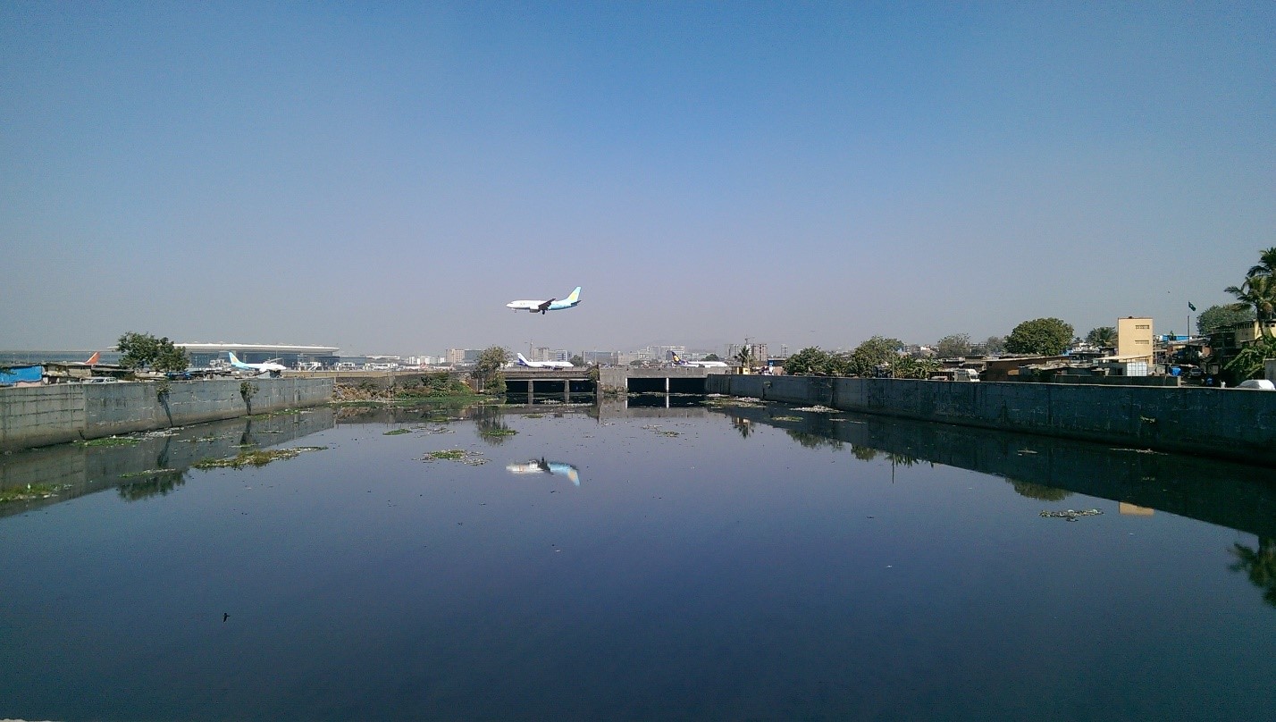
Descending into Mumbai and entering the newly built, swanky international airport terminal provides a first glimpse of the extremes that earned India’s financial capital the popular description of ‘maximum city’[1]. Vast expanses of slums surround the airport periphery, which appears like an island of tranquility and well-organized modernity amongst an otherwise – at least outwardly – chaotic cityscape of unregulated settlements, hectic construction activity and perpetually deadlocked traffic. In its most densely populated parts, a million people jostle for space across a single square kilometre.
Mumbai belongs to the world’s megacities, and is in flux. More than 20 million people live in the larger metropolitan area and 12 million in its core. Constrained by geography, surrounded on three sides by the sea and a creek, the city has long been grappling to find space for its expansive development.
Originally built on reclaimed land along a chain of seven islands, city planners have attempted to relieve pressure by promoting vertical growth, as well as channelling city development towards the inland by promoting the establishment of satellite cities and building an entirely new town, Navi (‘new’) Mumbai. These attempts have so far not succeeded in solving most of Mumbai’s problems – problems that tend to be social and political in nature.
Apart from spatial constraints, the future direction of city development is influenced by global capital flows, shifting political priorities at the national level and environmental changes, including those of climate change. Within Mumbai, spaces of development are composed of (the above) politicians, bureaucrats, scientists; (middle) environmentalists, civil society groups and (below) ordinary residents – rich and poor; spaces that are fluid, with various narratives and counter narratives clashing over contested versions and visions of urban development.
One of the major threats that Mumbai’s population faces is flooding. A key event that changed the discourse around disaster management and adaptation planning was the ‘freak flooding’ on the 26th of July 2005. On this particular day, extreme rainfall and high tides caused the main drainage channel of the city, the Mithi River, to overflow and led to extensive inundation that brought the city to a halt. At least 500 people lost their lives, thousands more were injured and the damages in economic terms were enormous.
The case of the Mithi River and its close co-relationship with a burgeoning city, evolving threats and livelihoods, provides a microcosm of the dynamics that come into play in Mumbai, the multiplicity of actors and their diverse framings of issues of flooding, pollution, uncertainty and risks. In an ongoing study, members of the NFR-funded project ‘Climate change, uncertainty and transformation’ conducted research on these themes in April 2016.
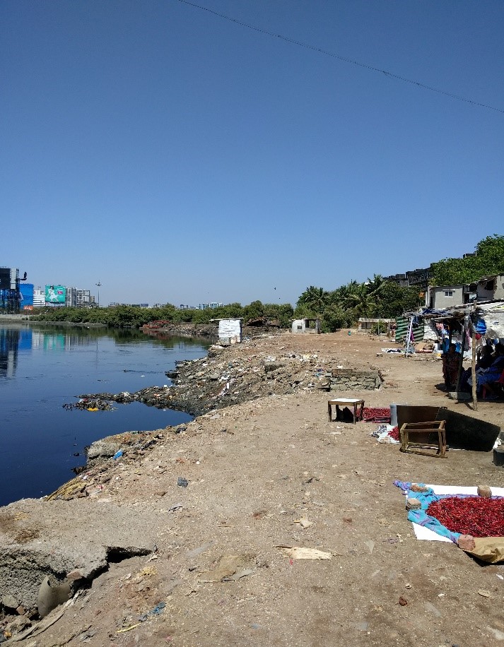
Flowing through the central and most densely populated parts of Mumbai for about 15 km, the Mithi was once considered a pure and free-flowing river, but is currently described to be more akin to a sewage channel. Dammed over the years with adjacent mangrove areas and flood plains taken over, the river has been veritably straightjacketed. Its banks are densely populated by what officials label as ‘encroachers’ and the river flow is clogged up by solid waste. Commercial interests, ecological concerns and community resistance intersect here.
Proponents of the affluent middle class envision a city that, through the vehicle of ‘riverbank development’, can become more attractive, green and liveable, along the lines of other ‘global cities’, such as Singapore. Developers and businesses are keen on using these lands for property developments and entertainment zones. Bureaucrats, environmentalists and scientists understand the removal of encroachers directly correlated with the rejuvenation of the river and the opening up of buffer land as key to improving the flow, thereby alleviating some problems associated with flooding. On the other hand, for the large number of residents directly living on the riverbanks and eking out marginal livelihoods, it is an affordable place to stay in the central parts of Mumbai, close to services and jobs. These various actors have been struggling to frame and implement their respective development visions across spaces.
Which vision of ‘transformation’ will ultimately prevail remains to be seen, but it is obvious that the dynamics at play emphasize growth and displacement over local communities and ecologies. It has to be remembered that the local slum residents provide a lifeline for the city through their cheap labour and dynamism and that they already live on the ‘margins’. Prospective planning of the Mithi environment, whether for adaptation or economic development, must come up with alternatives for the future that are just, inclusive and that address the concerns of the affected people as well as climatic extremes.
[1] Mehta, S. (2004). Maximum city. New York: Alfred A. Knopf.

Hans Nicolai Adam is an economist by training and is currently a Postdoctoral Fellow working on climate and development issues with a specific focus on India. His doctoral theses, completed in 2015 at Noragric, focused on understanding the role of social policy with respect to climate change adaptation in rural India. His research interests encompass a variety of interdisciplinary themes that include the science-policy interphase, adaptation policy, rural development and tribal development issues.

Synne Movik is a former Postdoctoral Fellow at Noragric, where she focused on Global Environmental Governance. She was involved in coordinating a project on the implementation of Norway’s climate and forest initiative, reduced emissions from deforestation and forest degradation (REDD), as well as a water and climate project in the Rufiji basin, Tanzania. She has a DPhil in Development Studies with a focus on water rights from the Institute of Development Studies in the UK. She is currently a Research Scientist at NIVA.

